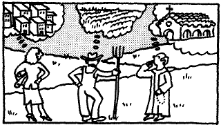
Observation. It is significant that 25% of Texas high school seniors reportedly do not know Mexico is the country immediately to the south because there is ample evidence of that geographic proximity writ large in the landscape all around them. if a student merely looks at the ethnic makeup of her class, at the nature of the cafes in his city, at the languages on the walls or signs of the community, it can be seen that there is a real presence of Mexico in Texas. Skill in observation helps develop a student's capacity to see reality, opportunity, or danger. This is part of the vital -- and necessary -- capacity to read the world around him or her. This is geography.
graphic
Speculation. The second essential skill -- speculation -- comes into play with all geographic knowledge. Geographers ask, Why does this landscape look the way it does? Has the natural or human-modified setting been significant in establishing the economic activity that goes on here? What groups have had a hand in creating the personality of this place?
This progression of observation and speculation is not only critical geography, it is critical thinking. And such intellectual activity is a goal for all education, at all levels of learning.
Analysis. The third foundation block of this educational structure is analysis. Once a person has read the landscape and reflected on the forces that have given it the shape we see, then a more thorough analysis of the dynamics of landscape creation must be initiated. Taking Baltimore, Maryland as an example, we can ask: What population groups have lived here? Why has the Baltimore Inner Harbor regained such vitality? How has American fickleness over the downtown been an influence on this city? This process of geographic analysis is an open door to real richness in the discipline.
Evaluation. Making use of the geographic skills that we promote is highly significant. Interviewers -- and the general public -- need to know that geographers are the best, most well-informed decision-makers in many policy areas because of their study of cultural as well as physical constraints on land use. The ultimate goal of geographic understanding is to have a better sense of how the world ought to be shaped, and to act on that understanding. Observation, speculation, and analysis should lead naturally to a more intelligent capacity for evaluating the merits of particular landscapes and their associated utility.
Classroom teachers, professors of geography, and authors of materials for each domain too often shy away from the need to provide a crisp and well-supported evaluation of landscapes. This disinclination to take a strong position may be a significant reason for the drabness of our profession in the eyes of the general public. Let the first three steps in this quartet of geographical perspectives move you, your students, your readers or viewers to development of a well-supported point of view. This approach not only helps clarify the content of geography, it also promotes an understanding of intent and application to the world around us.
These four processes are fundamental to all geographic enquiry . . . just as they are to investigative journalism . . . so listing and explicating them is a good way for the geographer to wean the interviewer from the misconception that placename geography is the be-all and end-all of geographic literacy.
Build on the base of Observation, Speculation, Analysis and Evaluation to highlight the Five Fundamental Geographic Themes.
The educational geography community has been efficient over the past six years in creating a series of fundamental themes to serve decision-makers in a search for a new form of classroom geography. These five themes of Location, Place, Human-Environment Interactions, Movement, and Regions have been a focus of the materials that the National Geographic Society has promulgated through its Geography Education Program and Alliance Network. Thousands of teachers have been through inservice and Teacher Training Institutes in which these Five Themes have been pivotal to geographic education.
By using such themes to focus on geographic issues such as Central American refugee flow to the US, the siting of sanitary landfills in all American cities, or the surprising new vitality of downtown America, you can begin to extend the journalistic understanding of geography. This will lead to the presentation of an expanded and more genuine view of geography.
For example, the theme of location -- which is basic to any geographic issue -- can be tied to observation and speculation in many ways. Point out that the Persian Gulf, located in the heart of the Islamic and oil-rich world, creates a powerful political axis. This locus of cultural and economic prominence is significant not only to the USA but to the entire globe. Similar lessons on the power of regions can relate to Eastern Europe, Central America, or the Panamal Canal. Topics change daily, but what persists is the role of geography in intelligently assessing events of current and potential significance.
Speculation about the human environment interactions that have led to the return of American business professional people to downtown -- whether in Baltimore, Los Angeles, or St. Louis -- is fertile ground for many geographic perspectives. Questions about land use, popular culture, interest in older building stock and architecture, and the persistent value of centrality all can be touched by discussion of current residential mobility and the related interest in rebuilding and repopulating the traditional central city.
Regions and analysis; place and observation; speculation and movement all can be wedded in geographic inquiry if you have real examples and real landscapes ready to parade before the mind's eye of interviewers. Let them initiate the discussion by asking about placenames, and then lead them to the real personality and significance of those places by demonstrating how fundamental themes in geography explain the current and past reality of placenames and their locations.
Major additional subfields in geography.
Beyond the Five Themes, there are specific subfields in geography that demand explicit mention as you wrestle with the question "What is geography if it is not just placenames and map identification?" The list of such subfields is vast -- as all of us know and as very few others care -- but there are three that should be given special attention in your effort to tutor the American media on the essence of geographic literacy.
Spatial analysis. If location and place name geography represent absolute fundamentals in geographic literacy, then spatial analysis must be studied if one is to comprehend the patterns created in these places. Spatial analysis is the order that the geographer makes of these Trivial and, Global Pursuit questions.
Ask the interviewer about the search behavior he or she used in getting to campus for the interview. Ask about the network of newspapers or stations that will receive the finished article or video. Ask about the ethnic origin of the journalist and race and discuss the roots and routes of his or her family's migration to America, or to your state. And then turn to the map or globe in your office and talk about the origins of the patterns of refugee flow that are so profoundly changing American demography and classrooms.
The act of making order out of the reality that is expressed on the maps around your office is the exercise that will demonstrate the power of spatial analysis as a geographic tool. Have the interviewer pick up any map and ask you a question about it ... try your skills at thinking on your feet as you point out the strands of geographic reality that link cities, ports, regions, countries and continents to each other. Just make certain that you discuss this process of observation, speculation, analysis and movement as an exercise in basic geography. We all know that it is, but no one else does. It's time we took credit for these thoughtful, and thought-provoking encounters with places.
Environmental Perception. Even as I type this term I feel as though I have slipped through a time warp and returned to an era long gone. Some of us passed through the 1960s and 1970s when environmental perception was a vital and banner-borne term. As I write it now I feel as though I have to explain and define it. How can something as basic as reading and evaluating the landscape around us, slip into faddish decay?
It is time to once again take a strong stand on the simple fact that human institutions and technology are manipulating the environment at a pace that is unprecedented. This manipulation affects the people who live, work, and visit the world's myriad places. The products of this change are varied, and very costly. Whether you cite landscape changes such as farm land-to-suburbs, old factories-to-boutiques, or wilderness-to-forestland-to-parkland, you are conjuring up the basic geography of environmental perception. Just as observation is a sine qua non for every geographic exercise, environmental perception -- the many views people have about place -- is an essential perspective if one is to make any sense of the world. You can talk about a second grader trying to learn about her community or a political activist promoting recycling instead of a sanitary landfill. Both serve as excellent examples of someone finding utility in geographic awareness. Both are exploring fundamental and vital examples of environmental perception and manipulation.
Resource Evaluation. In some of the conversations that we have all gotten into as part of this media blitz, someone of at least my age has stepped up and spoken of early geography classes that spent much time on the location of iron ore and the associated iron and steel industry. Hearing this, I am struck by the paradoxical emotions of relief and dismay. The "relief" comes because someone did teach basic geography. The "dismay" comes from the fact that all this soul conjures up and recalls is the so-called "capes and bays" geography, or inventories of placenames and geographical features.
There is, however, an economic and cultural baseline that drives much of our learning. Natural resources have long played a fundamental role in the economic development of a region. Geographers ask, Where is petroleum found? How significant is coal as an energy resource? What nations -- such as Japan and Switzerland -- have been effective in overcoming resource deficiencies ... and what has enabled them to achieve great economic success even in the face of that lack of domestic resources?
These questions are cardinal to understanding the nature of the world that we are attempting to fathom. These questions are cardinal to geography. Geographers must own up to the significance of natural resources as basic to geographic literacy.
Conclusions
As in so many geographic discussions, these themes are only part of the cosmos. There are many other subfields that are worthy of identification as axial to geography, but spatial analysis, environmental perception, and resource evaluation are absolutely essential to understanding the substance of geography.
Observation, speculation, analysis and evaluation may not capture all of you as the essential foursome of intellectual activities that lead to geographic understanding, but they all promote thoughtful geography.
Likewise, the Five Fundamental Themes do not embrace all geography, nor do all geographers embrace this quintet . . . but such themes do represent the powerful teaching job done by the AAG, NCGE, AGS, and NGS (the membership organizations of GENIP) during the last five years. We geographers must build on the widespread success of that job even as we point out that there are dimensions of the discipline that transcend those themes.
Our burden, really, is to take interested interviewers -- and by extension, an interested and concerned public -- and make them all realize that geography is much, much more than placename and map geography. If we, as a profession, are only going to have 15 minutes of fame, let it be spent in stimulating people to realize that our discipline and profession look far beyond place lists and blank maps with numbers.
Don't let the teacher just point to the place, the map, and assume that the geography lesson is done. Make certain that instruction in location is followed by exploring the elements of geography that illuminate its personality and geographic role in the world through the use of these several expansive, provocative, and essential themes. Recall that Garrison Keillor's professor feared that the classroom geography teacher would lose heart and skip South America. Let us work not only to have the teacher and the school maintain the teaching of that continent, but teach about it with a full range of well understood geographic themes.
These avenues of exploration go way beyond placename and map geography.
They lead right to the heart of geography.
They express the essence of geographic literacy.
(Illustrations from GENIP publications and C L. Salter's 1987 "Geographic themes "'scroll, Suzanne Shimek Dunaway, artist)
In the box :
Does the student anticipate any further change? Are the people of the city who first built and used this part of the city going to return to it? How can a student respond to that question -- what evidence is there in the landscape that will support his or her speculation?
Observation. Take a class into the central part of the city. Position the student on a major intersection, one that still looks as though it used to represent great centrality. Ask the students what they can see from that vantage point.
Students will note the impressive nature of the buildings that are in the locale. There will be -- in almost all cases -- a look of substantial architecture around the corner. These same buildings will, however, probably also appear rundown and even abandoned on the second floor and above.
Have the students talk about the ethnic mix of the population walking along these streets; what sorts of land use and retail activity characterize this scene? Are there any signs of earlier transportation systems such as trolley tracks or overhead wires? What are the current modes of transportation? Where does someone park in this area?
Have the students talk about the look of the streets, the street trees Q), the repair and maintenance of the buildings. Have them, from this same corner, try to figure out through observation the ways in which this locale fits into the overall economy and culture of the city.
Speculation. What was the role of this part of the city; of this particular intersection? What has happened to it? What has replaced this locale as the city center? Has one locale replaced this, or have many locales?
Why did people stop using it the way that it was probably utilized when it was first built? What forces led to the change that is evident in this landscape? What role has been played by economic forces? cultural forces? transportation technologies? ethnic shifts in the city? How might a student put together a decade-by-decade historical geography of this intersection?
What will be the role of this locale in three years? In ten years? What evidence does the landscape hold for such a speculation? What sort of feeling does the student have about this area? How does he or she think he would feel in five years at the same corner?
Analysis. Having observed and speculated about the past, the present, and the future of this intersection and its landscape, what needs to be learned to put together a more objective and substantiated historical geography of the scene? What sources would exist in the local library? What local histories exist that chart the block by block growth and change of the central city for this place?
What evidence can be gathered for understanding the economic role this place has played for the past century or so? Where does the student find the data to answer such a question? What role might conversations with long-time residents of the area play in such an analysis? What about old newspaper accounts? What about Sanborn maps of the area? Of any local map series? Of photographic records of the past and the present?
Where do you search in the library for solid answers? What questions do you ask of people in the area? What geographic literature does one turn to gain a better sense of the evolution of the central city and its landscapes during the past seven or eight decades?
Evaluation. The final demand of this landscape is the student's evaluation of the success or failure of the scene to meet the needs of the city. Every built environment (and the city center is among the most built of all environments) is a direct reflection of society, economics, technology, aesthetics, fads, and architectural styles of the moment. The student in this phase of this exercise attempts to comment on how well this landscape is working. And for whom? Is this a productive, an intelligent, and equitable, and a resourceful use of the landscape?
The overall exercise: OSAE, Can You See? is a steady and useful progression of geographic exploration. It builds on the absolutely essential skill of Observation and then leads to critical Speculation and subsequent geographic Analysis. It concludes with a demand on the student to Evaluate the landscape being studied. These skills are absolutely basic to geography and they can be developed from the early grades until and through life as a professional geographer. We should all be able to say that we can see, speculate, analyze, and evaluate the landscapes around us.
- K.S.
This document was first published in Focus magazine (Summer 1990) 26 - 29. Permission to republish the material in conjunction with these lesson plans was granted by Focus [on geography], nn Mar 2001.
Go to Top
Back to Greg's Home Page Back to Previous or Current Class Work Back to WebQuest Lessons
(geoglitercy.html)gen 16 April 2001 This document first appeared on the WWW on 02 Apr 2001